
Forecast Journal:
2025 Forecast Contest Week 1 Outlook
--- Posted on 2/24/25 --- The 2025 spring forecast contest begins March 1st, which as of the time of writing is less than one week away! But will we start the contest off with a bang or a whimper? April and May of 2024 were incredibly active periods for severe weather - especially tornadoes - but March 2024 got off to a relatively slow start. So how does this March look?
Where we're at and where we're going
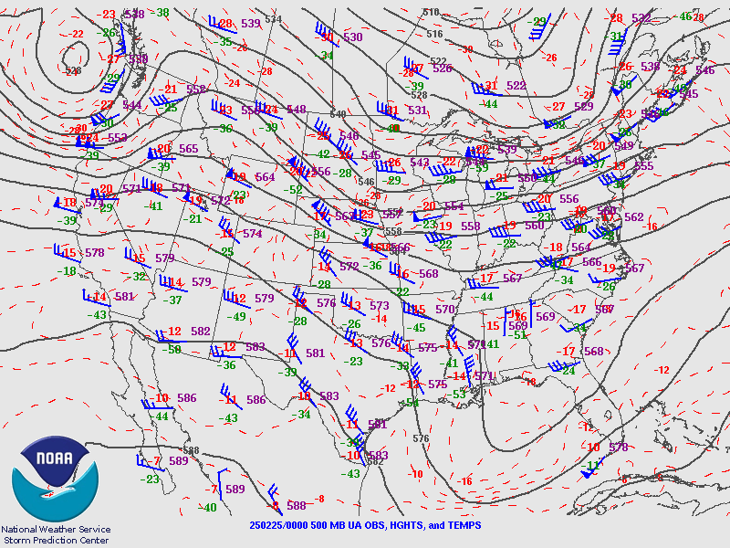
Over the past 1-2 weeks, the upper air regime could best be characterized as a broad northwesterly flow regime with unseasonably strong and persistent upper ridging across the western third of the country. This type of synoptipc pattern typically favors weaker, lower-amplitude upper troughs propagating southeastward across the central and eastern parts of country, which typically bring influxes of cold continental air and help keep appreciable Gulf moisture displaced well offshore. The observed 2/25/25 00z 500 mb chart is good example of this regime (shown below).
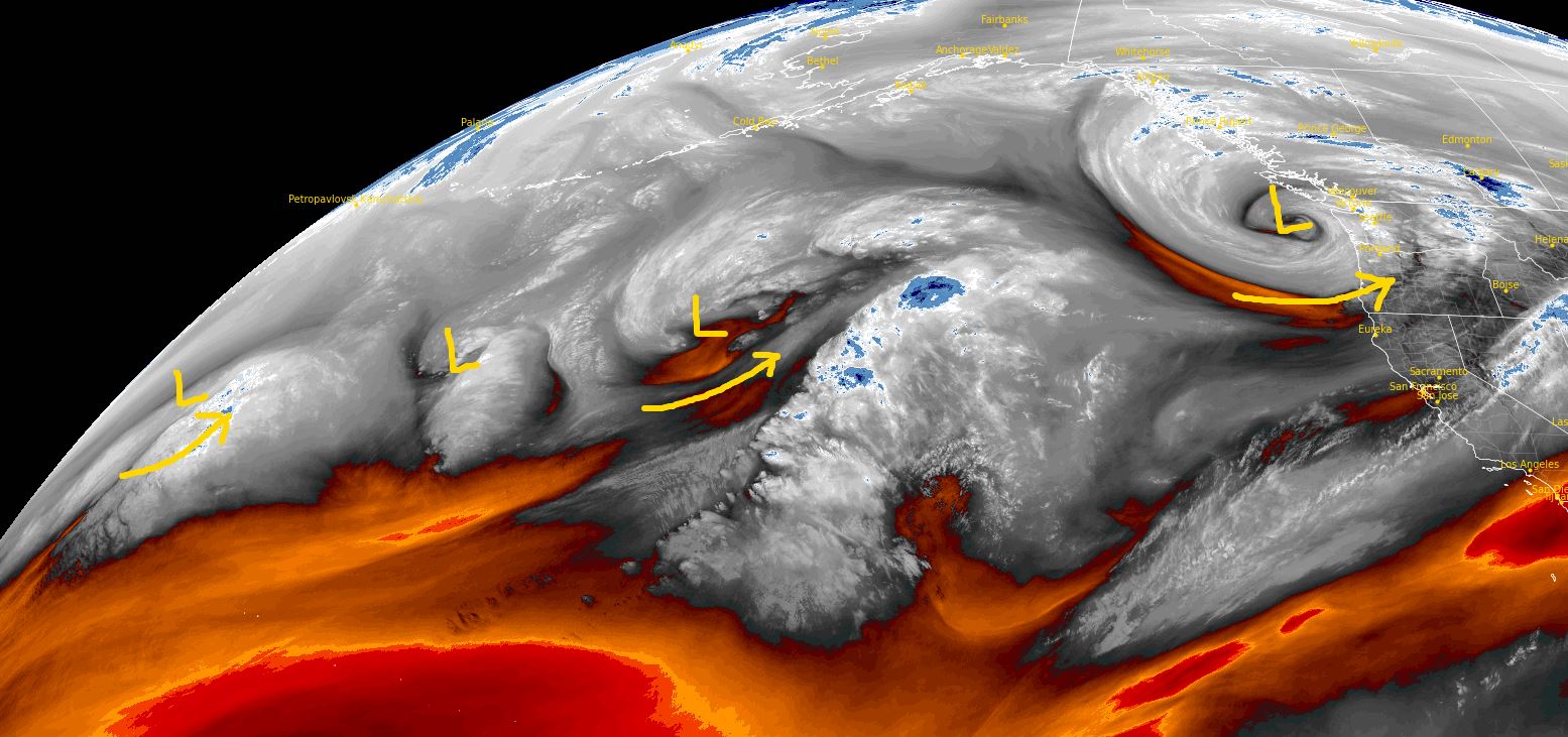
However, long-range guidance suggests a regime change is likely by early March. Long-wave ridging over the west is currently forecast to break down by March 1st as strong zonal jets over the northern Pacific break down into Rossby waves as they approach the West Coast. These higher-amplitude waves are then forecast to migrate into the central/southern latitudes next week and may support some severe weather potential. Recent water-vapor imagery shows a wave train across the northern Pacific, which should result in a gradual de-amplification of the upper ridge over the West. This will mark a shift from a northwesterly flow regime to a more typical spring time pattern characterized by progressive, higher-amplitude waves moving across the central portions of the country. Attendant to these waves are stronger surface cyclones, better moisture return, stronger wind shear, and consequently, better severe weather potential.
March 1st - 5th Outlook
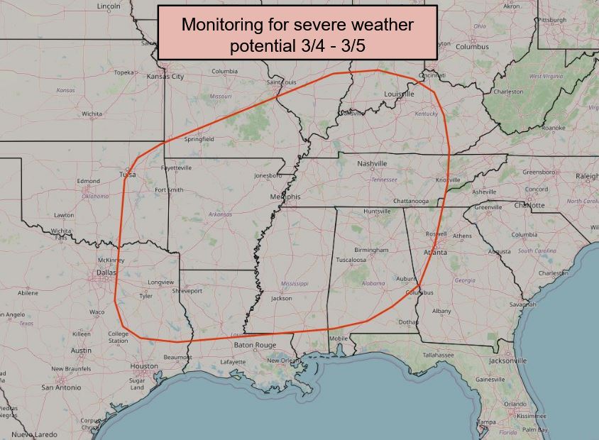
The latest ECMWF/GFS solutions suggest the last of these upper disturbances will eventually become the first upper wave that migrates into the Southwest/southern Plains by early next week. As it stands, the timing of the first wave may be too late for any appreciable severe weather potential on March 1st, but could support at least some severe weather threat across the southern Plains on Sunday, March 2nd. This potential will be highly dependent on the quality of moisture return, which is dependent on the strength and trajectory of the upper wave. Long-range ensembles continue to show considerable spread in this regard, so overall confidence is low. Regardless, this first wave will play a crucial role in advecting usher moisture back northwad into the southern Plains and lower MS River Valley ahead of a more pronounced wave that is anticipated during the March 4-5th (Tue/Wed) time frame. While there is still a *lot* of spread in deterministic and ensemble solutions regarding the timing and intensity of the second upper trough, there is a consistent signal for a strong synoptic wave with a deepening surface low and a robust plume of 55-60 F dewpoints into the MS Valley during the late Tuesday to early Thursday time frame. While traditional metrics for assessing the convective environment are somewhat poor (e.g. MUCAPE or SBLI), the overall synoptic regime aligns with typical severe weather events for early spring, so it's something to watch!
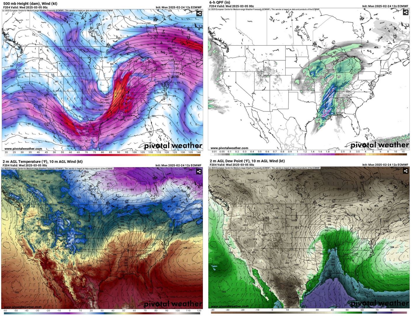
Obviously, details at this range are highly uncertain (keep in mind that the second, more prominent upper trough isn't even observable in GOES-18 imagery yet), but the overall signal is there our first chance at an appreciable severe weather threat for the contest period could be during the first week of March. As a reminder, based on the new scoring system, events that produce above-normal numbers of LSRs will yield the highest scores. For March, the average number of LSRs on a convective day is 51. So there is definitely potential for a skillful forecaster to take an early lead in the opening week of the 2025 forecast contest!
hidden text!